If you want to truly understand Cape Cod’s lighthouses, you need to see them from the sky, where the coastline, cliffs, and sea reveal the full story at once.
You can walk up to a lighthouse. You can climb the stairs. You can stand near the base and snap photos. But if you want to grasp why these towers matter, you need altitude. From above, the land curves, the sand shifts, and the ocean shows its force.
And if you're already thinking about booking something meaningful like the Cape Cod Day Charter from Boston. Add more meaning to your trip and enjoy your stay at Cape Cod with Helicopter Tour Boston.
Cape Cod light houses were built to guide ships through dangerous waters. That makes sense when you see them from above. You notice the sandbars stretching like pale fingers into the sea. You see how the coastline bends like an arm reaching into the Atlantic.
From ground level, you see a tower. From the air, you see the hazards it protects against.
You also notice patterns. The lighthouses are not random. They mark curves, inlets, and exposed edges. Once you see that layout from above, it clicks.
That is why an aerial lighthouse tour feels different. It answers the “why” before the “how.”
You probably recognize Nauset Light. It is the red and white striped lighthouse that shows up on chocolate bar wrappers. On the bluff in Eastham, it feels charming and bright.
But when you rise above it, you see something more dramatic. The cliffs beneath it are steep. The ocean is wide and restless. You realize it had to be moved inland years ago because erosion threatened to pull it into the sea.
From the air, Nauset Light looks bold yet fragile. It stands against wind and waves like a stubborn guardian. That contrast only makes sense when you see the full coastal sweep.
Highland Light in Truro is the oldest lighthouse on the Cape. It first began service in the late 1700s. That history carries weight.
When you fly above it, you notice how high it sits on the cliffs. You see the drop below. You see waves hitting the shoreline far beneath.
From the parking lot, it feels peaceful. From above, it feels strategic. You understand why ships once depended on it during storms.
You might ask yourself, “Is this just about pretty views?”
No. It is about context. And altitude gives you context.
Chatham Light stands at the elbow of Cape Cod. Currents here are strong. Sandbars shift. This has long been one of the most important navigation points along the coast.
From the sky, you see fishing boats moving below. You see long arcs of shoreline. You see how the Atlantic wraps around the bend.
This area also connects visually to nearby waters where marine life gathers. From above, you see how everything connects. Coast. Current. Wildlife. Navigation.
That layered view is something you simply cannot piece together from ground level.
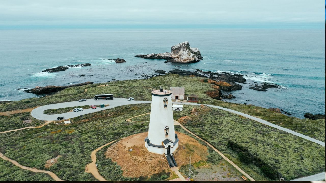
Race Point Light sits near Provincetown at the northern tip of the Cape. It feels remote when you drive to it. Sand stretches wide. The wind feels strong.
From the air, it becomes even more striking. The lighthouse looks isolated against vast dunes and open sea. You see how ships once relied on it to navigate the treacherous waters where Cape Cod Bay meets the Atlantic.
The shoreline curves dramatically here. From above, the geometry feels almost artistic.
And this is where you realize something. Cape Cod light houses were placed with precision. They were not placed as decorations. They are lifelines.
Wood End Light stands near Provincetown Harbor. It is quieter than some others. It does not have the same bold stripes.
But from the air, its location becomes powerful. You see how it marks the entrance to the harbor. You see boats drifting inside calm water while waves break farther out.
It feels like a gatekeeper. From the ground, you might miss that relationship. From above, it becomes obvious.
Now let’s talk about the practical side. You might be wondering, “Is this worth the effort? Can I not just drive there?”
You can. But summer traffic to Cape Cod is slow. Bridges clog up fast. A two-hour drive can stretch much longer.
With the Cape Cod Day Charter, you lift off from Boston and reach the Cape in about 30 minutes. You skip traffic. You gain time. You experience the journey itself as part of the adventure.
That is why this ranks among the six must-do experiences offered by Helicopter Tour Boston. It blends speed, privacy, and panoramic views in one smooth arc.
When you sit in the helicopter, the feeling surprises you. It is calm. The cabin feels steady. You wear a headset and talk to your pilot.
Below you, the Cape stretches in curves. Lighthouses appear like chess pieces placed with care. You begin to see how they align along the coast.
You notice things you would never catch from the road:
It stops being a checklist of landmarks. It becomes one connected landscape.
You might pause and ask yourself, “Is this really worth it?”
If your goal is a simple visit, maybe not. But if your goal is to understand the Cape, to see it in one sweep, then yes.
You avoid traffic.
You avoid crowds.
You gain perspective.
You experience multiple landmarks in one flight.
It is not just transport. It is elevating in every sense.
Once you land or finish your aerial loop, there is more to explore.
You can walk the Cape Cod National Seashore. You can bike the Rail Trail. You can explore Provincetown’s art galleries. You can enjoy fresh seafood by the harbor. You can watch the sunset at Race Point Beach.
Each activity adds a layer. But the aerial view ties them all together.
Is it better to see Cape lighthouses from the ground or from the air?
From the ground, you see the details and history up close. From the air, you see how each lighthouse connects along the coastline. The aerial view reveals the full shape of the Cape.
What can you see when flying over Cape Cod’s coastline?
You see beaches, dunes, cliffs, and waves in motion. Sandbars and harbors form clear patterns from above. The coastline feels wide and alive.
Why does the Cape look different from the air?
From above, the land curves naturally along the Atlantic. Each lighthouse becomes part of a larger coastal system. The scale feels much greater.
Is an aerial view worth it if I already visited the lighthouses?
Yes, because the experience is completely different. Walking gives you closeness, but flying gives you context and distance.
What makes an aerial coastal view so memorable?
The open perspective changes everything. You see miles of shoreline at once. The sense of space creates a lasting impression.